Greenway Trails
Getting There & Parking
Features as You Walk
More Trails
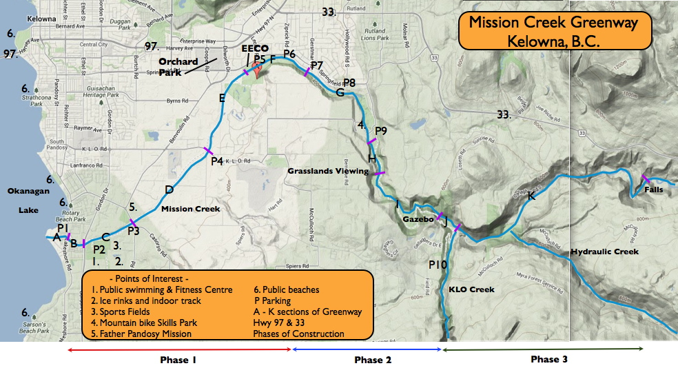
Our 'You are Here' Map
Interpretive Information
Mission Creek Trails
For most of it's distance, the Greenway is only on one side of the Creek. In some areas, however, it appears on both sides and offers the opportunity of walking a loop. At other points along the Greenway, side-trails offer interesting sites. Or the trail splits and reforms to one trail further upstream or downstream. The location of each trail is indicated by letters A to K, found on the trail features map. Visitors are reminded that no motorized vehicles are permitted on the Greenway.
Areas with a Greenway trail on both sides of the Creek:
Beginning downstream;
- Lakeshore Rd to Gordon Dr (area B)
- Gordon Dr to Casorso Rd (area C) (wetlands, restoration project, doggy area, WFN land, Father Pandosy Historical Site, Casorso Marsh.)
- From the EECO upstream to Cottonwoods (Mindy Tran) pedestrian bridge (area F). View the kokanee salmon spawning channel and the many Sutherland Hills walking trails.
Areas where the Greenway splits:
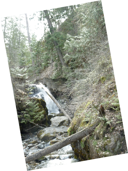
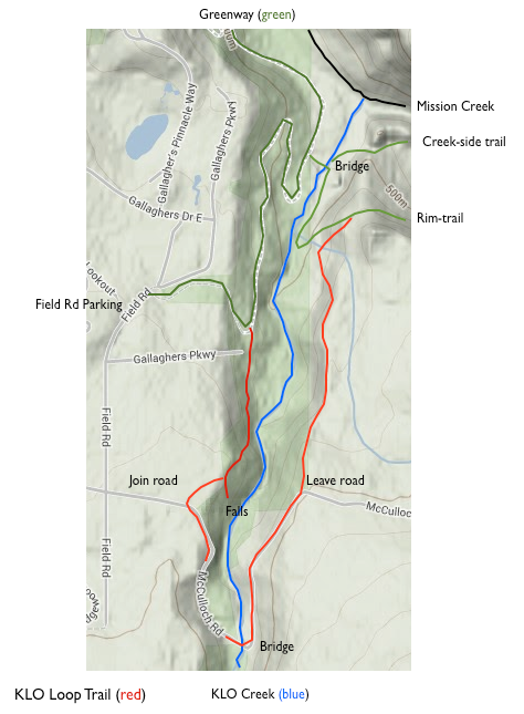
The most interesting split area is K. Here the Greenway either travels along the riparian zone of the creek, or high on a rim trail, to Hydraulic Creek. On the High-Rim trail you can take spectacular photos of Pinnacle Rock and Layer Cake Mt. and ask yourself what caused those layers. Don't get the KLO/Hydraulic 'loop' confused with the KLO Creek canyon 'loop' (described below and shown in red on the map).
 Side-trails :
- Upstream from the spawning channel (area F), continue for a short distance upstream on the south (left) side of Mission Creek. Note the dyke structure which dates back to the turn of the last century. Also note the location where the boy scouts had a suspension bridge some 60 years ago.
- Gallagher's Canyon and the Rock Ovens area (area J). This side-trail is passed by many visitors, yet it is one on the most fascinating areas on the Greenway. If you are traveling downstream from the Field Rd parking area the trail leaves the Greenway just as you begin to asend up to the Pinnacle Rock observation area and the Gazebo. If you are traveling upstream, drop down the hill from the Gazebo and head downstream along the stream edge at the bottom of the hill. Signs will help you. Once you are there, note the caves. Families lived in these some 80 years ago. Also note Gallaghers Canyon wall. Imagine the torrent of water that carved this cliff during runoff after the last ice age 10,000 years ago. Picnic tables are provided but please remember to take your garbage away with you.
- KLO Creek Canyon 'loop' (area K). KLO Creek joins Mission Creek at the downstream end of area K. Trails extend on both sides of KLO Creek from the Greenway along Mission Creek, up KLO creek to McCulloch Rd. This trail provides appreciation of how deep KLO canyon descends. Join this loop on the west side of KLO Creek at either the caretaker's cabin down the hill from the Field Rd parking lot, or at the top of the hill before McCulloch Rd descends down to the KLO bridge. Join the east KLO trail either as it leaves McCullouch Rd walking east up from the KLO bridge, or at the junction of the KLO east side trail and the Greenway upper Rim-trail to Hydraulic Creek. (See the map on the right, trail in red)