Mission Creek
Mission Creek is located in the Okanagan Valley within the Southern Interior of British Columbia. At the outlet of Mission Creek into Okanagan Lake is Kelowna - a city with a population of 100,000 to 200,000. The climate is semi-arid with temperatures averaging 32C in summer and -5C in winter.
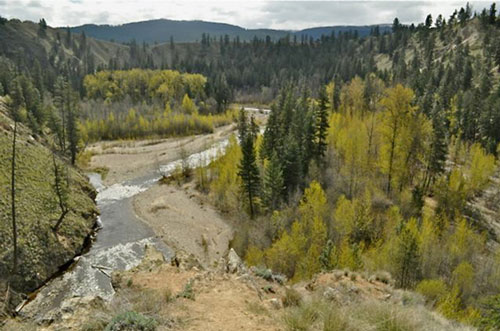
Mission Creek drains the second largest watershed in the Okanagan Basin (only the Vernon watershed is larger) but has the highest altitude and therefore the greatest water contribution to the 100 km long Okanagan Lake. At least 25% of the lake water comes from the Mission Creek watershed, and this proportion increases to 35% during dry years. Water flows approximately 50 km down the creek from an elevation of 1,800 m before slowing as it moves across the flood plain on which Kelowna is located. The focus of the Friends of Mission Creek is mostly on the last 25 km before the creek flows into Okanagan Lake. It is along this route that our Greenway trail is located.
The temporal drainage pattern for Mission Creek has one peak flow each year during the spring snowmelt period. Thereafter the discharge in the creek decreases progressively through the summer, the fall, and the winter, to only increase the next spring. This is in dramatic contrast to coastal rivers which have a similar spring flow peak but also substantial peaks during mid-fall. An expectation of climate change is a shift in the spring runoff peak to earlier in the year, perhaps by two weeks. Simultaneously, the agricultural growing season is expected to start two weeks earlier, but also extend an additional two weeks in the fall. Given that climate change predicts a decrease in annual precipitation, water for agriculture and domestic consumption is going to be difficult to source, and even more difficult with an expanded growing season. Add to that an ecosystem need that is not being met today, and competition for water will become even more serious.
The Mission Creek sub-basin has a number of tributaries. Almost all have their origin lakes modified for agricultural water storage purposes. With a growing human population in the valley the irrigation districts that regulate that water now have the additional burden of supplying the ever increasing domestic population. Two irrigation districts are the main users of Mission Creek water - Black Mountain and South East Kelowna irrigation districts. They are the dominant providers of basin agricultural and domestic water, other than Okanagan Lake water extraction by the City of Kelowna. In 2000 water licenses on Mission Creek flows exceed 100% of the water in the creek.
Mission Creek has been influential in the development in this area of the Okanagan Valley. Prior to the arrival of European settlers, Mission Creek was home for a substantial native population. It is thought that they diverted the adult migration of kokanee salmon into a side channel that is close to the location of the radio transmitting tower near the convergence of Casorso and Benvoulin Roads. These fish were then dried and stored as a winter food supply. Some reserve land is still maintained by the Westbank First Nations at the South-West location with respect to the bridge across Mission Creek on Casorso Rd.
History
European history in the area has also been closely tied to Mission Creek - from the 1859 building of Father Pandosy's Mission where the first fruit trees in the Valley were planted, to early 20th century irrigation works - the first settlers used the creek as an important transportation route. The waters provided power for a grist mill and gold was found along its banks in the 1800's. The creek was once the site of active placer gold mining activity. Placer gold pits that yielded 2 or 3 ounces per man per day can be seen along the trail today. And, for several years the caves, called the rock ovens, at the base of Gallagher’s Canyon was home for several families.