The Friends of Mission Creek Society
History
The Friends of Mission Creek Society was incorporated in 1996 and immediately set out to find the funding to acquire the land to develop a Greenway trail along Mission Creek as it cuts through the City of Kelowna.
The purposes of the "Friends" include the preservation, conservation, and rehabilitation of Mission Creek and its environment, and to assist in the acquisition of lands to be dedicated as part of the Mission Creek park system.
Greenway Project - Phase 1
The Phase 1 Greenway project was announced in 1996 and was the most successful community funded project in Kelowna's history. Landowners along the Greenway donated in excess of 16 acres of land valued at more than $300,000. Phase 1 project extends from Lakeshore Road to Ziprick Road, a distance of 7.3 kilometres, and was completed in 1998. It is a universal access trail that is well used all year by walkers, hikers, runners, bicyclists, wheelchair users, and equestrians. Usage is estimated at over 1,000 people a day.
BC Heritage River Designation
In 1997 Mission Creek was granted "BC Heritage River" status by the BC Heritage Rivers Board.
In awarding this status the Board said:
"The current major effort to restore and manage the natural qualities of the waterway through a model process of stewardship within an urban environment is particularly significant."
Greenway Project - Phase 2
Phase 2 is 9.2 kilometres long and extends from Ziprick Road to KLO Creek, beyond Gallagher's Canyon Golf Course. The trail enters Mission Creek canyon just beyond the East Kelowna Road bridge. The canyon is a wilderness area with unique geological features. With the loss of so many area trails as a result of the 2003 Okanagan Mountain Park fire, the opening of the Phase 2 trail was welcomed in the Spring of 2005.
Many spectacular geological features exist on the Phase 2 trail, including Layer Cake Mountain, Pinnacle Rock (J2 and K2), Gallagher's Canyon (J4), and Hoodoos. The total trail length (Phase 1 and Phase 2) is 16.5 kilometres.
Greenway Project - Phase 3
Construction of the Phase 3 Greenway began in 2015 and continues. It starts at KLO Creek (the end of Phase 2) and will eventually extend upstream along the edge of Mission Creek to Hydraulic Creek. Visitors will be able to take a spectacular Rim trail that parallels the Creek-side trail from KLO to Hydraulic Creek. The views of Pinnacle Rock and Layer Cake Mountain (J2 & K2) are excellent.
Near the beginning of Phase 3, after crossing the KLO bridge, a 'loop' connector trail travels up the East side of KLO Creek to McCulloch Rd and back down the West side of KLO creek to your starting point on the Greenway. At the McCulloch Rd intersection you must walk west on the road for 300 m, then right onto the trail that takes you down the west side of KLO creek. Your travel on this 'loop' reveals views of the lower KLO Creek canyon and KLO falls (J3).
At the upstream end of the 'loop', as it meets McCulloch Rd., visitors may soon be welcome to travel up KLO Creek, to Angel Springs and perhaps as far as the Myra Canyon Railway Trestles.
Environmental Education
The Society participates in several environmental initiatives to bring awarness of the unique environment we have in the heart of Kelowna. We enjoy developing and showing exhibits at the Mayor’s Expo, and the Kokanee Salmon Festival each year. We assist the Regional District of the Central Okanagan in organizing the Kokanee Fun Run each fall. Particularly, we raise funds to support our $1,600 annual grant ($900 and $700) to two local schools that have the greatest proportion of their student body participating in the run. The run distances are 3, 6, 12 and 16 km. The annual grants support environmental education projects organized by school teachers.
 Conservation & Restoration of Mission Creek
We also partner with a number of other organisations in a long term project to restore Mission Creek to its former ecological glory prior to dyking (see Conservation/Restoration menu).
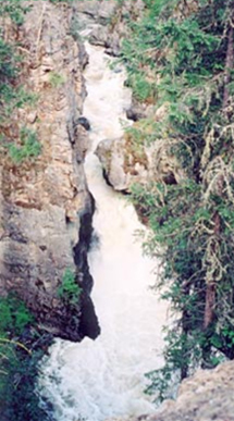
K5 - Mission Creek Falls. The falls are 66 feet high and this narrow gorge carries one third of all the water that enters Okanagan Lake each year.
